The epicenter of typhoon PODUL will pass directly through the city of Sanya, Hainan, China on the evening of August 29, 2019 at about 20 hours.
However, typhoons are natural occurrences, their trajectories are unpredictable, for example, this typhoon PODUL appeared in the Pacific Ocean east of Luzon Island, Philippines on the morning of August 27, 2019, and it was first predicted that typhoon PODUL would reach Hainan Island on September 1, however the typhoon has accelerated its movement and will reach Hainan a few days earlier. However, different weather services differently predict the trajectory of the typhoon PODUL even less than a day before it appears on Hainan Island.
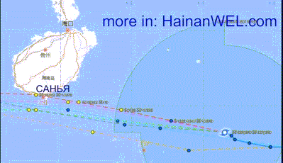
In the video at the top of this article, we plotted all the possible typhoon trajectories PODUL, where the orange dashed line is the typhoon trajectory predicted by the Taiwan weather service, the blue dashed line is the typhoon trajectory predicted by the United States weather service, and the gray dashed line is the typhoon trajectory predicted by the southern typhoon Korea, the pink dotted line is the typhoon trajectory predicted by the Hong Kong weather service, the green dotted line is the typhoon trajectory predicted by the Hong Kong weather service Japan, the red dotted line is the trajectory of a typhoon, predicted by the China Weather Service.
As you can see, only the Chinese weather service predicts that the trajectory of the typhoon PODUL will go right through the center of Sanya on Hainan Island at about 8 pm on August 29, 2019, while the hurricane wind speed will reach about 90 kilometers per hour, therefore, strictly scientific , typhoon PODUL did not reach the status of typhoon a bit and is classified as an intensified tropical storm.
In the video at the top of this article, you can also see a cloud map and a radar map of precipitation along the path of typhoon PODUL to the city of Sanya on Hainan Island at the time of this writing.
You can also order weather and accurate satellite images on our website, along with a cloud radar map of clouds and rains at any current time and over any city in Hainan, China.
You can watch hundreds of videos of excursions on the island of Hainan here: https://vk.com/videos-51202698